

Written by James E. Kamis on 20OCT2015

Figure 1 – Offshore Washington / Oregon seafloor bottom topography (bathymetry).
As the Paris Climate Talks begin, the mainstream media has ramped up output of alarmist man-made global warming articles, this time focusing on increased methane gas plumes. Specifically, methane gas bubbling up from the seabed at several locations off the coast of Washington state. Methane gas plumes that they say are the result of man-made atmospheric global warming and indicative of a pending disaster.
Here's what we're told:
Human CO2 emissions have warmed the atmosphere, which has acted to warm mid-ocean depth levels in localized areas off the coast of Washington. This warmed seawater has heated, and therefore destabilized, selective and underlying seafloor methane-rich geological rock layers. These destabilized methane-rich geological rock layers are now emitting methane gas into the overlying ocean and are indicative of an impending worldwide catastrophic methane release. Methane gas is a so-called greenhouse gas with a potency 23 times greater than carbon dioxide (CO2).
Scary stuff!
Here is what the media is not telling you: natural methane gas has been seeping from seafloor locations off the coast of Washington state for thousands of years; the methane gas seeps mentioned in the recent alarmist articles are located along known geological fault trends; offshore Washington fault trends are known “natural” methane emitters; one the world’s most well-documented/famous deep-ocean heat and fluid pulses occurred from a fault zone off the Washington coast in 1986; and that recent regional Pacific Ocean warming is related a to geological heat-flow-induced El Niño, not man-made global warming (see references at end).
So are we on the verge of a worldwide catastrophic methane emission disaster as per these national media reports, or is there a local, geological explanation to recently observed methane gas emissions from seafloor locations off the coast of Washington state?
Here are the facts without the hysteria:
Let’s begin by taking a moment to review the image atop this article (Figure 1 - click to enlarge) that shows the topography of the seafloor off the coast of Washington in the greater region of methane gas bubble emissions. The prominent black lines in the deep ocean on the left/west side of the image are major seafloor geological faults. It is important to note that these fault escarpments (very steep banks) form two completely straight lines that are at right angles to each other.
This relationship shows that the faults are related and generated from the same geological force. When powerful planetary forces push on rock layers, they break/fault in predictable linear crossing patterns. That’s exactly what has occurred in this region of offshore Washington. These faults are part of the very well-known and major Juan De Fuca Rift / Fault System which is associated with the large tectonic Pacific / North America Plate boundary.
Next let's look at the map of the offshore Washington sea bottom methane bubble locations (see Figure 2).

Figure 2 – Map showing locations of the 168 bubble plumes used in the study.
Takes a moment to let your eyes adjust, for once you study the pattern of the methane emission bubble locations you will notice there is a distinct linear red dot (new methane release) pattern, a distinct linear green dot pattern (known from literature), and that the two linear trends are at right angles to each other. Figure 3 is demarcated to clearly show these two linear trends of methane gas bubble locations.

Figure 3 – Methane gas bubble location with linear trends highlighted, and an interesting parallel trend to the north.
To further illustrate the similarity of these two maps, known faults, and methane bubbles, Figure 4 places the maps side by side. You will notice that the linear trend direction and the angle the trends intersect are identical. This shows that the methane bubble locations lie along known active fault lines, and in are the result of the same geological forces that created the Juan De Fuca faults. This has important geological implications.
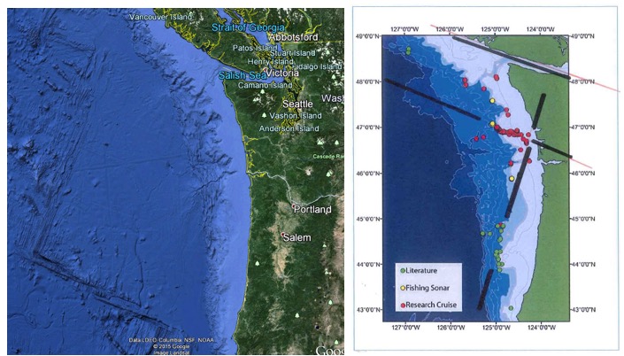
Figure 4 – Matching straight line trends of the known Juan De Fuca Rift System
faults and methane gas bubble locations (red and green dots), and an interesting parallel trend to the north along the coastline.
It indicates that the root cause of the increased methane gas bubbles is from the heat and fluid flowing up the fault trends and NOT from atmospheric warming of a localized region off the Washington coast. This means the source of the methane bubbles may or may not be unstable methane rich and shallow seafloor rock layers. In fact, it is more likely to be methane gas brought up along the faults that are tapping super-deep natural methane pockets. This is the known and proven process behind methane bubbles / plumes along the Juan De Fuca Ridge.
If this was the only piece of significant geological information, it would still be prudent for the media to present this information to the public so they would know other (and more likely) non-global warming explanations were possible. Indeed, there is actually even more pertinent geological information just by doing a simple Google search.
Some might argue that since the Juan De Fuca is 250 miles east of the methane gas bubble locations, hasn’t the geology changed? No. Upon review of the fault maps for regions just onshore from the methane gas plumes, the trends, angles, and reasons for faulting are again very similar to the trends discussed above.
Still, other geological information can be obtained by reviewing this previous Climate Change Dispatch post concerning a large deep-ocean heat and fluid plume along the Cleft Segment of the Juan de Fuca Ridge fault system discovered in 1986. This mega-plume event was so significant it spawned the formation an entirely new branch of the United States Geological Survey. This group was tasked with studying the impact of heat and fluid emissions (liquid methane and CO2) from deep-ocean faults and hydrothermal vents. Also, numerous research articles cite methane emissions from faults and hydrothermal vents along the Juan de Fuca Ridge.
Climate scientists and politicians who strongly favor the theory of man-made global warming are now saying the debate is over. They say there is no credible evidence showing anything but a warmed atmosphere is about to create all sorts of climate-related disasters, including massive ocean methane emissions. Here we show that a very brief review of offshore Washington methane gas bubbles shows natural geological forces at play, and has nothing to do with climate change.
Is all this geological evidence absolute proof that geological forces are controlling the methane gas bubbles? Of course not. Nothing in science is in absolutes. That is how science is supposed to work. You present all the pertinent information, then considerate it, test it openly and without restraint, reproduce it, and allow others to review your work. A more responsible media article would have, or at least should have, presented the geological backbone behind these increased methane plumes.